Transit App: a smarter way to navigate your city
 Finding your way around big cities is generally a challenge, even if you live there. You might know the best bus routes, or have mastered the metro, but you can still be in trouble if a service is unexpectedly cancelled and you're left looking for an alternative.
Transit App is a free Android and iOS app which helps out with a host of tools for planning journeys around and across your local city.
The app covers around 100 metropolitan areas, including most North American cities, and a scattering in France, along with London, Rome, Milan, Berlin, Mexico City and Nairobi.
Wherever you are, Transit App understands all your local transport options: bus, subway, metro, uber, car2go, train, streetcar, light rail, ferry and more.
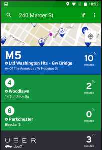
Fire it up and you’ll get the very latest information on all your nearest options, their departure and journey times.
Plans can change, so Transit App keeps you as up-to-date as possible, even showing where your bus or train is on the map in real time (or a guesstimate, anyway).
If you're preparing for a trip, the app can help you plan A-to-B trips via all supported transport modes. Important routes may be marked as favourites for easy recall, and you can review schedules and routes later, even while you’re offline.
Maintaining accurate times across so many transport types is horribly difficult, but Transit App seems to do better than most, and with a 4-star + rating on Google Play and the App Store it looks like most users are happy. If your area is covered then we'd give it a look.
