

Google Maps 'For You' tab comes to iPhone
Google Maps is probably the best navigation and maps application available today -- it is chock full of useful features. While Apple Maps is actually pretty great these days, the search giant's offering still reigns supreme. It isn't hard to see why Google's app is so good -- the company collects data on its users to create a more focused experience. In other words, if you are willing to trade privacy for convenience, Google Maps is sure to delight you.
As a way to leverage some of the information it collects, Google Maps introduced a new "For You" tab for Android users earlier this year. It is essentially a personalized section based on the data Google has collected on the user. Today, iPhone and iPad users in more than 40 countries get to take advantage of this feature too. In addition, the search giant announces it has expanded "For You" Android availability to users in more countries too.
Major Google Maps update brings real-time public transport updates, music control, and more
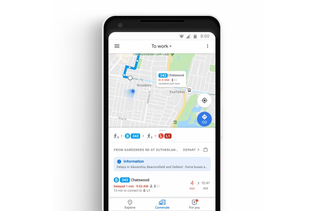
Google is pushing out a big update to its Google Maps app with the aim of making your daily commute easier. One of the biggest additions is support for mixed-mode commutes -- those journeys that involve multiple modes of transport -- and to help with this, there's also real-time information about the location of buses and trains.
But it doesn't end there. Google Maps now also supports Spotify, Apple Music, and Google Play Music podcast and music playback to help keep you entertained while you travel.
Google Maps now has a voting option to help plan group events
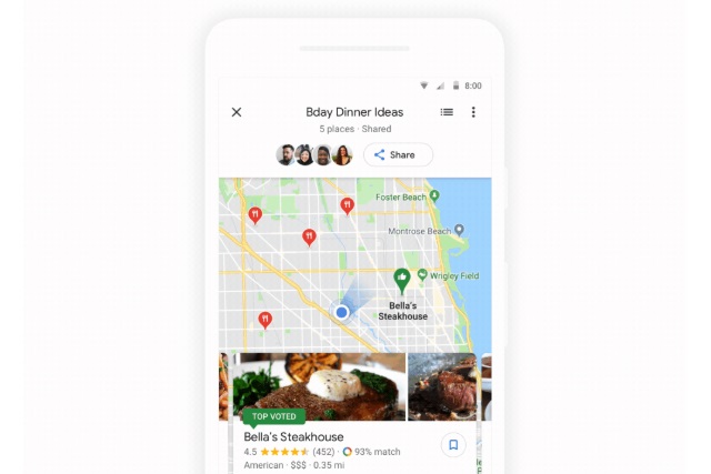
Both the iOS and Android versions of Google Maps have received an update that will be welcomed by anyone who has ever struggled to arrange a meet-up place, or a dining location with a group of friends.
A new voting function makes it easy to gauge opinion and see which location is most popular without having to resort to endless messages, or arguments in group chat. It's a simple idea, but one that can help avoid many heated arguments and allow you to reach a decision faster.
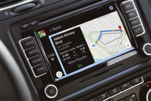
Google Maps 5.0 for iOS offers CarPlay support with iOS 12
Before any trip, I like to research. Where’s the best place to eat, pick up a decent coffee on the way, other interesting points of interest and more.
Google Maps makes this easy. Research online, add a new folder to your places and start saving pointers along your intended route. When you land, simply refer to Google Maps and navigate to your saved locations. Easy. Well, it would if your hire car let you use Google Maps.

Google and The American Red Cross partner for World Blood Donor Day
Whenever there is a tragic event, such as a natural disaster or large-scale terrorist attack, people turn out in droves to donate blood. This is very noble, but such a donation is not only needed during publicized tragedies. Every day, hospitals around the world use donated blood to save lives.
Each year, we celebrate World Blood Donor Day -- an annual occasion to raise awareness regarding the necessity of this life-changing donation. On this day, people often want to donate, but it can be hard to know where to go. Thankfully, Google is partnering with The American Red Cross to make finding such a destination even easier. A Google employee has even chosen to share their personal story about how donated blood saved a family member's life.
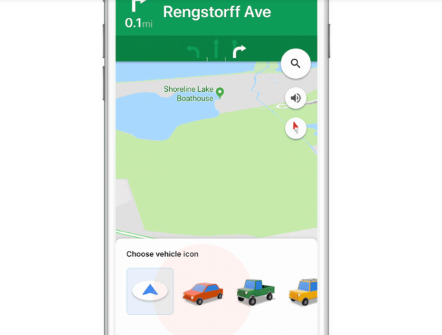
Google Maps for Apple iPhone gets new vehicle icons for some reason
Want to know a secret? Google apps on iOS are often much better than the Android versions. Don't ask me why -- you'd think the search giant would show more love to its own platform instead of Apple's, but oh well. Ultimately, iPhone owners get the best of both worlds.
Today, Google announces a new Maps feature that is apparently exclusive to iOS. Before Android users get too upset, they should know it really isn't a big deal. In fact, it is kind of odd that the search giant is even hyping the seemingly useless feature. What is it, you ask? Well, on Google Maps for iOS, you can now replace the usual blue arrow that represents your vehicle with an icon of a car, truck, or SUV. Umm, OK...

'Where's Waldo?' comes to Google Maps for some reason
Today, Google announces that it is bringing the "Where's Waldo?" franchise to Google Maps. If you aren't familiar, this is a picture book series in which the reader has to find "Waldo" -- a man wearing a striped sweater. By design, he is hard to find -- he is hidden in plain sight by blending into his surroundings. Exactly why Google is doing this is a mystery, but OK, whatever.
Tomorrow is April 1, a date that represents "April Fool's Day" -- a holiday where people play pranks on each other. In recent years, technology companies -- including Google -- have used this date to announce fake news; usually an absurd product or other silliness. Surprisingly, this Where's Waldo? announcement is real and not an April Fool's Day prank.
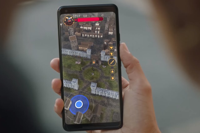
Google opens up Maps API to game developers
Google is giving developers the chance to build games based on real-world maps by opening up the Maps APIs to them. On top of this, Google is bring Maps to the Unity game engine so developers can make use of real-time map data.
Titles such as Jurassic World Alive, The Walking Dead: Our World and Ghostbusters World will make use of augmented reality to create truly immersive gaming experiences. Developers have access to over 100 million 3D buildings, roads, landmarks, and parks from over 200 countries, allowing for great flexibility.
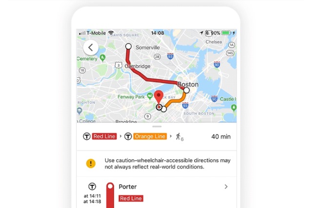
Google Maps gains wheelchair accessibility info in several cities
Google is adding some important accessibility information to Maps, letting users see whether or not routes are navigable by wheelchair. The company says the extra data will be useful not only to wheelchair users, but anyone with mobility issues -- as well as parents pushing kids in a stroller.
Starting in London, Tokyo, Mexico City, Boston and Sydney, wheelchair accessible routes are being added, and more will follow as Google working with transport companies to gather the necessary information.
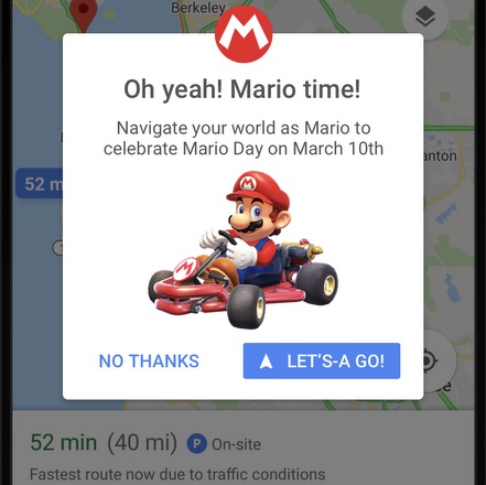
Celebrate 'MAR10 Day' with Mario Kart on Google Maps
My first-ever console was Atari 2600. My favorite game for it was Mario Bros. -- it was before the brothers became super on Nintendo Entertainment System. It was Super Mario Brothers on NES that made me -- and countless others -- huge video game fans, however. My love for Mario, Luigi, and the rest of the Nintendo world, remains strong to this day.
To celebrate Mario, an annual holiday has been established -- MAR10 Day. Get it? It is on March 10, as the abbreviation looks like the word "Mario." Well, Google is apparently getting in on the Mario love, as it is bringing the plumber to its Maps service for a limited time.
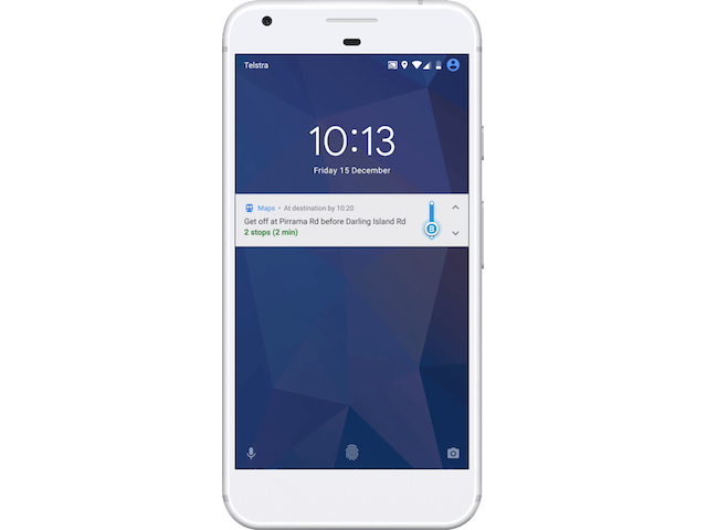
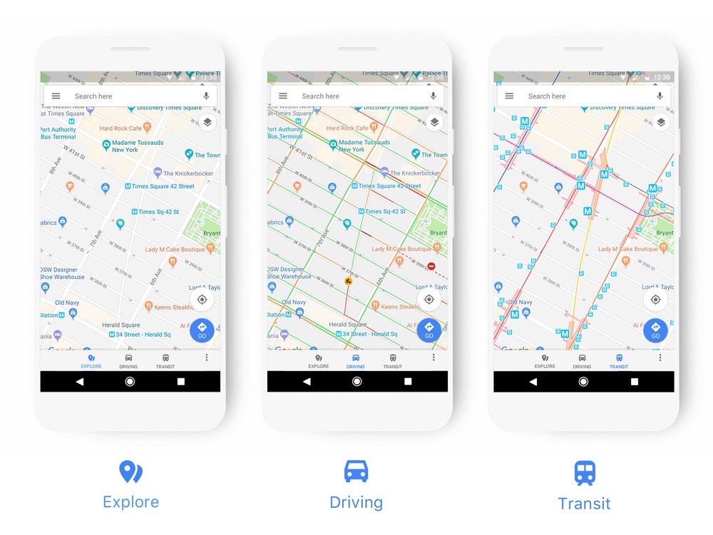
Google Maps for Android gets step-by-step directions for public transit navigation
When some people -- such as suburbanites -- think of Google Maps, their minds likely go to motor vehicles, such as cars, motorcycles, and trucks. People also use it for other types of transportation, however, such as walking, biking, and mass-transit. Google Maps works rather well for these various means of traveling, adjusting both the route and estimated time based on your selection.
Today, Google Maps for Android gains a new feature that will greatly benefit folks that ride the train or bus. You see, the app will now provide step-by-step directions for public transit navigation. In other words, the search giant is helping you to avoid missing your stop.
Google updates Maps with a more modern look
Maps is one of Google’s best products, and it gets updated on a regular basis, with changes and new features debuting all the time.
Today the search giant takes the wraps off a redesigned Maps, which sports a new look that Google says "better reflects your world, right now."
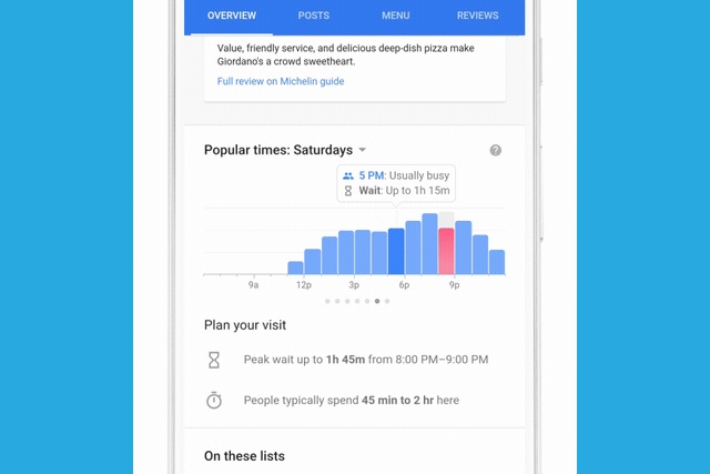
Google adds restaurant wait times to Search and Maps
Search for a restaurant using Google, and you're already told the times of day at which a particular place is busiest. But Google is about to make this information even more useful.
The fact that a restaurant is busy at 3PM on a Thursday afternoon doesn't necessarily mean you'll have to wait ages for service -- there may be more staff working, for instance. A new update to Google Search -- and Maps is to follow -- means you'll be able to see estimated wait times as well.

Google Maps to lose controversial cupcakes and calorie counting feature in iOS
Google has announced that it is removing a feature from the iOS version of Google Maps that estimated how many calories could be burned off by walking a particular route. Based on "strong user feedback" Google took the decision to remove the feature that had been rolled out to a number of users.
Google faced an online backlash when the feature launched as it used pink mini cupcakes as a measure of calorie burning -- a 2 kilometer walk, Google Maps informed users, would burn 112 calories, or one mini cupcake. The feature was criticized for being a possible trigger for people with eating disorders.

Street View comes to Google Earth VR
Virtual reality is hardly new, but the technology is finally getting to a point where it is fairly affordable and easy to use. It still has a long way to go before it can truly be considered mainstream, as for now, it is largely just for enthusiasts and gamers. There will need to be some truly great non-gaming uses to propel VR to the next level.
Google Earth VR is the type of application that could get people excited about virtual reality, and today, it gains an amazing new feature -- Street View. Yes, with the help of either an Oculus Rift or HTC Vive, you can experience Street View in a more immersive way.