
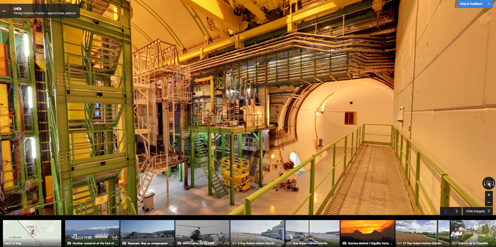
Google Street View visits CERN, Higgs Boson not captured in images
CERN, the European Organization for Nuclear Research (yes the acronym doesn't work unless you speak French) and LHC, the Large Hadron Collider, have been in the news quite a bit in recent times. The search for, and possible discovery of, the elusive Higgs Boson, the so-called "God-particle", is a major step forward for science.
Now the Google Maps Street View team have hung up their snorkels, dusted off their hiking boots, sailed home from the Galapogos and set their sights on a bit of science.

All Aboard! Google Street View sails to the Galapogos
You will not be the first to explore the islands' biodiversity, and you won't be arriving on the HMS Beagle, but you also no longer need to face the hardships of a long sea journey to visit the Galapogos. Google Street View has made the trip for you and, as the team always does, it recorded every moment so that you can visit without leaving your computer.
The search giant partnered with the Directorate of the Galapagos National Park and Charles Darwin Foundation in order to capture panoramic imagery of the small island group. The company hopes the data will not just be a source of enjoyment for Street View users, but also "play an instrumental role in the ongoing research of the environment, conservation, animal migration patterns, and the impact of tourism on the islands".
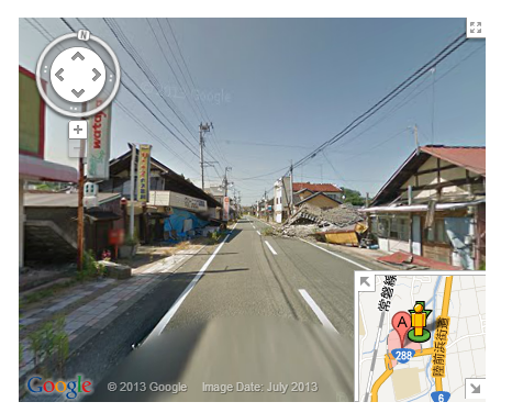
Aftermath of a tsunami -- Google Maps tells the tale
On March 11, 2011 a magnitude 9.0 earthquake struck off the coast of Japan, but despite the extremely high intensity of the tremor itself, it was the resulting tsunami that caused the real damage. Most notable, and scary, was the meltdown of three reactors at the Fukushima nuclear plant.
Now, two years after the tragedy that cost more than 15,000 people their lives, Google Maps, through Street View, takes users back into the teeth of this disaster.

Google Street View takes you to the zoo
"Someone told me it's all happening at the Zoo". Google's Street View team has traveled around the world from coral reefs to canyons and down the trails of National Parks. This time the trekkers caught a break with something a bit more relaxing than a miles long hike or a dive in an area known for its sharks.
Now the team visits zoos, allowing you to get a sneak peak of a place you wish to visit, or simply enjoy the view from the comfort of your chair. "Lions and tigers may be standard attractions, but starting today, you can also use Street View to see the panda bears noshing on bamboo and tumbling around the Chengdu Research Base of Giant Panda Breeding in China. More than 30 percent of this endangered species calls this important conservation and breeding facility home", says Deanna Yick, Street View Program Manager.
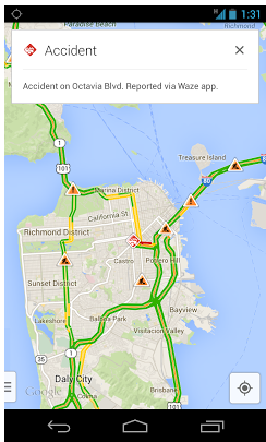
Google Maps and Waze -- the integration begins
Google purchased mapping firm Waze back in June, bringing two services that many mobile users feel are among the best on the market under the one roof. The acquisition led to speculation that the unique features offered by Waze would slowly be rolled into Google. Much of Waze's information is crowd-sourced, such as accident reporting, traffic delays and even police radar.
That speculation begins leading to fruition today as the search giant rolls out step one. "No one likes getting stuck in traffic. That’s why the Waze and Google Maps teams are working together to harness the power of Google technology and the passion of the Waze community to make it easier to navigate your daily life", says Brian McClendon, VP of Google Maps.
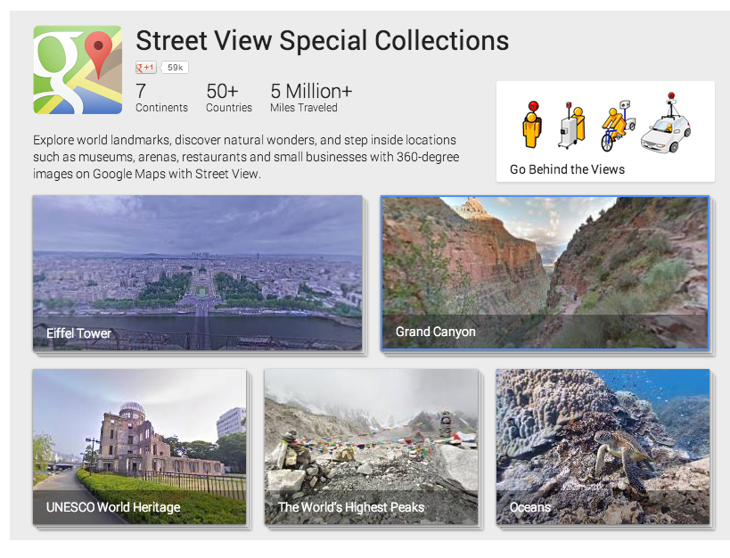
Google Maps unifies exploration, and you don't need to leave home
Google Maps has become adventurous -- what began as mapping, turned into street view of roads around the world and then morphed to bigger things, like underwater dives and hikes down amazing trails. All of this could be found, though it needed to be searched, but now the company wishes to unify all of this data in one location.
From the oceans to the lowest depths of the Grand Canyon, the search giant's team has traversed many of the coolest and most remote locations around the globe. And, a new website, appropriately named "Views" collates this data into a single location, including such far-flung locals as the Great Barrier Reef and Mount Everest.
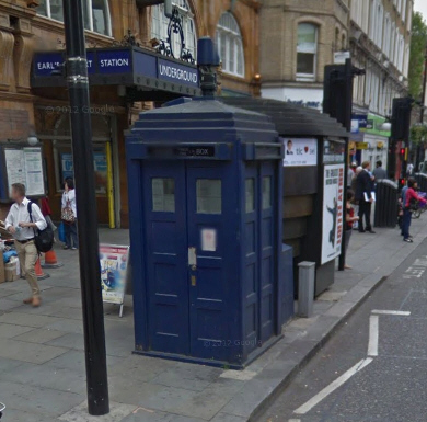
Google Street View lets would-be companions step inside Doctor Who's TARDIS
Like many British people, I grew up with Doctor Who. Looking back, some of the episodes of my youth that had me hiding behind the settee in fear were laughable rather than scary, but back then we didn’t know any better. Doctor Who these days though is a much more polished affair, with better effects, more convincing aliens and improved storytelling.
If you’re a fan of the Doctor and have always dreamed of going on adventures in his TARDIS but have never been lucky enough to have the iconic blue police box materialise in front of you, now is your chance thanks to Google and a hidden Street View Easter egg.
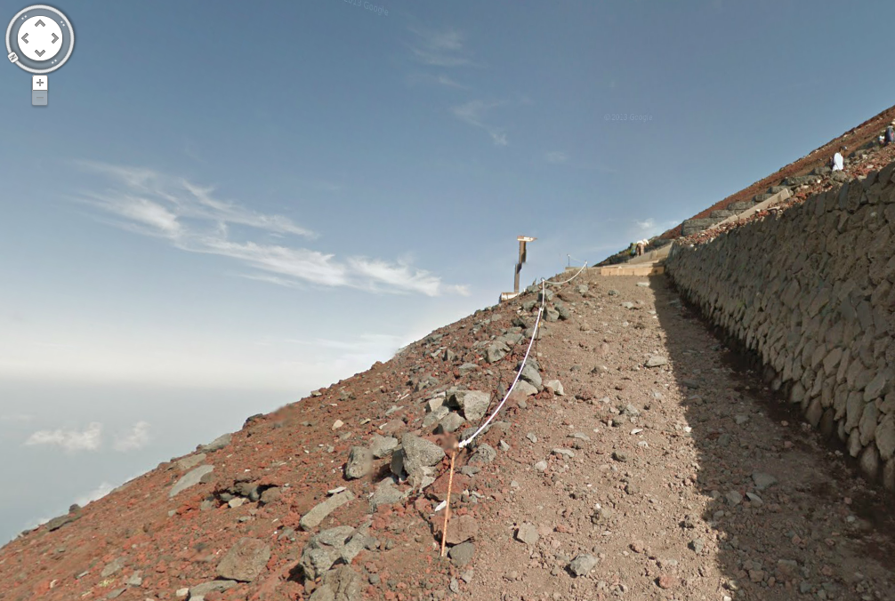
Scale the heights of Mount Fuji with Google
Google has previously sent its Maps team beneath the waves around the Great Barrier Reef, up the tallest mountain in the world, and into the mile deep depths of the Grand Canyon. Most recently the team scaled the heights of iconic Japanese landmark Mount Fuji, with the familiar Street View cameras firmly strapped to their backs.
Today the search giant rolls out images of Japan's volcano for those who either cannot get there or do not wish to climb the 3,776 meters to reach the summit. "The currently dormant volcano has inspired countless haiku and woodblock prints over many centuries, and around the world, its perfect conical shape has become one of Japan’s most iconic symbols", says Setsuo Murai, Head of Geo Partnerships for Google Japan.
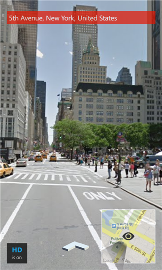
The new Google Maps arrives on iPhone and iPad
Google showed off a new version of Google Maps for the web at its I/O conference back in May, but made the updated preview invite only. Yesterday, the search giant finally opened up the new Maps to all -- no sign up required. Just go to Google's Explore Maps page, click the Try Now button, and you’re ready to start using it.
In addition to that, a week after Google rolled out a "new mapping experience" for Android smartphones and tablets, the firm has updated its app for iOS devices, introducing the same enhanced search and navigation features, as well as an optimized iPad design.

Google introduces a 'new mapping experience' for smartphones and tablets
Google has started rolling out a new version of Google Maps for Android devices, with plans to update the iOS edition "soon".
According to Daniel Graf, Director, Google Maps, the updated app builds on the version Google released for the iPhone last December, but improves on it by adding additional search and navigation features, as well as a dedicated design for iPads and Android tablets.
Google unveils updated Maps
This comes as little surprise, with rumors and leaks being rampant, but Google today unveils a new version of its popular Maps application at its I/O conference. A sign-up page had briefly been available earlier in the day, allowing users a glimpse at the new features. Then of course, there is a listing for "Google Maps: Into the Future" right on the conference site. Now we receive confirmation.
The new update brings a number of features that do, in fact, bring the service "into the future". The updates are for both mobile (tablet and smartphone) and browser -- some for each.
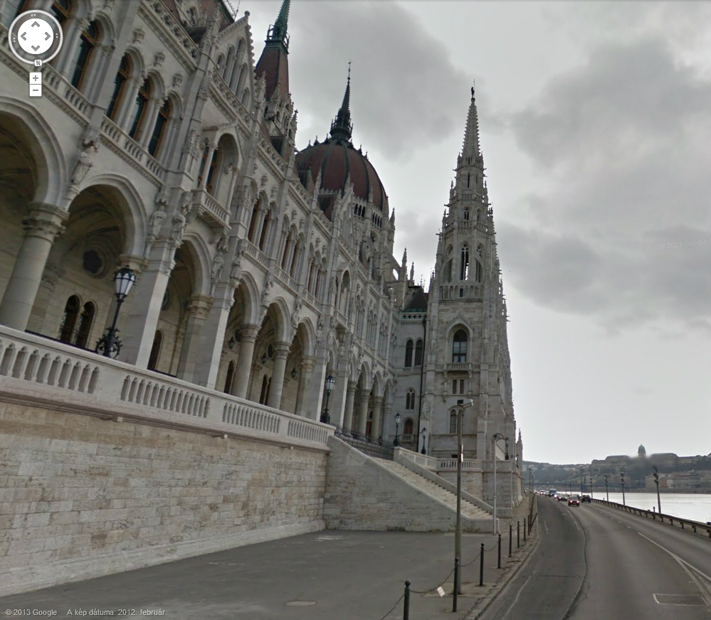
Google Street View hits 50 country milestone
Google Street View, which started with a few major cities in the United States back in 2007, has now expanded to 50 nations. Ulf Spitzer, Program Manager for Google Street View, announces today the latest round of updates which brings the service to two more countries, rounding up the new total to half a century.
The latest additions are Hungary and Lesotho. Spitzer also tells us that, in addition to the new countries, the mapping service is also expanding coverage in other locations. "We’re also refreshing and expanding existing Street View coverage in France, Italy, Poland, Romania, Russia, Singapore and Thailand. And, we’ve added new special collections of a host of picturesque spots -- using our Street View Trike technology -- that include Portugal’s Pena National Palace, or the Sha Tin Che Kung Temple in Hong Kong or the Kilkenny Castle in Ireland," Spitzer says.
Google Q1 2013 by the numbers: $13.97B revenue, $9.94 EPS
Google may be a company of many personalities -- browser and operating system developer, connected-device manufacturer, fiber-optic Internet servicer, search giant and social network, among many others. But the core business is still about one thing: Advertising, as calendar first quarter results, delivered today after the closing bell, show.
Revenue rose 31 percent to $$13.97 billion, year over year; operating income, excluding Traffic Acquisition Costs, was $3.48 billion, up from $3.39 billion. Net income climbed to 3.35 billion up from $2.89 billion. That's $9.94 earnings per share, including costs associated with discontinued operations.
gMaps for Windows Phone features updates to Driver Mode, Latitude and Street View
Even though Google has yet to release an official Google Maps app for Windows Phone, third party developers already offer a number of competent alternatives. One of the most popular ones, and my personal favorite, is gMaps which comes with a comprehensive feature set and, bar its name, could even pass as the real deal.
Today, DreamTeam Mobile, the team of developers behind gMaps, announced a new update to the popular Google Maps client. The app now touts further improvements for Driver Mode, Latitude and Street View. Let's go through each, one by one, and see what changed.
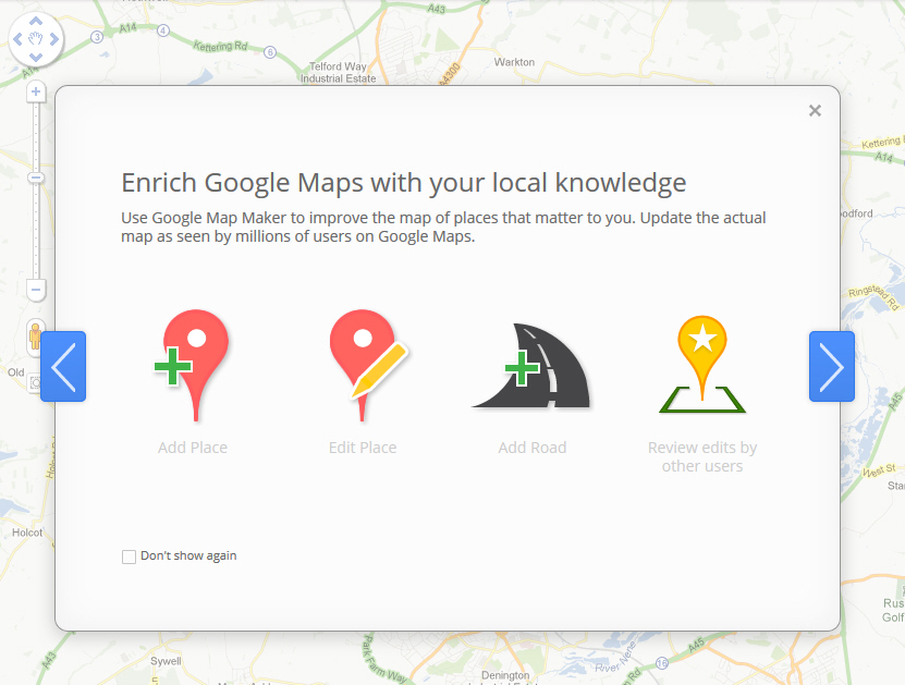
Google finally brings its Map Maker tools to the UK
Google’s digital maps are some of the very best in the world, and getting better all the time thanks to contributions and improvements from an army of users who submit additional details such as roads, rivers, railways and building outlines using Google Map Maker.
Map Maker was initially only available to users in more poorly mapped countries (such as Vietnam, Jamaica, Iceland, Cyprus, and Pakistan), but after successfully introducing it into territories like the US, Australia, New Zealand, Canada, and France, Google has finally made the tools available to residents in the UK.